Saint-Barthélemy may be famous for its beaches and villas, but the island also has roughly fifteen marked hiking trails winding through volcanic hills, coastal cliffs and secluded coves. BARNES Saint-Barthélemy picks four of the best, from the family-friendly Colombier trail to the summit of Morne de Vitet, the island's highest point at 286 meters (938 feet).
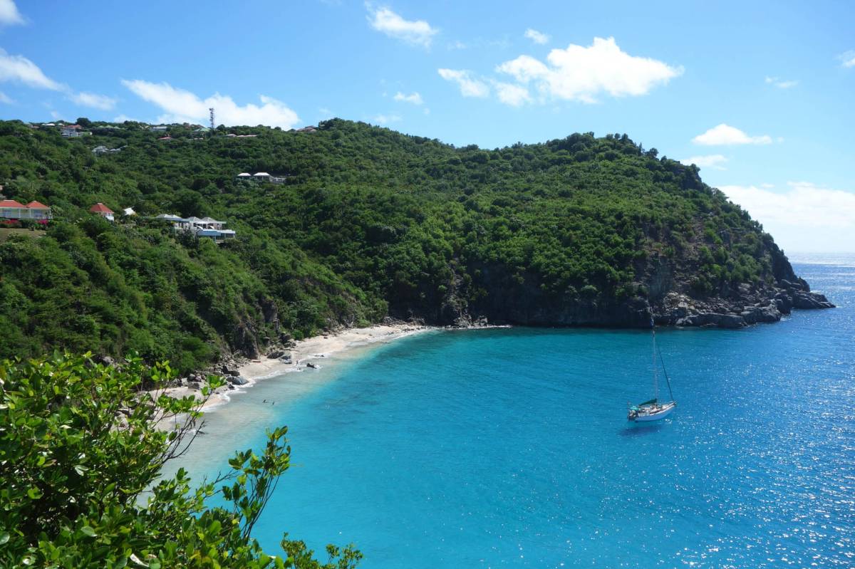
The Colombier trail starts at the parking lot at the end of Colombier Road, past the village of the same name. The path is about 2.5 km long and takes 25 to 35 minutes on a dirt-and-rock track with a moderate elevation gain of around 200 meters. Dry-stone walls and "Turk's cap" cacti line the first stretch, typical of the island's arid landscape.
Several viewpoints along the trail reveal the northwestern coastline and the small islands of Chevreau and Frégate. Below, Anse de Colombier gradually comes into view. Reachable only on foot or by boat, this bay sits within a marine nature reserve where sea turtles are regular visitors. Snorkelers will find some of the clearest waters on the island here, making it a natural complement to the diving and snorkeling spots in Saint-Barthélemy.
Fort Karl sits on the southern ridge above Gustavia, reached by a stone stairway off the road to Shell Beach. The climb takes 15 to 20 minutes and tops out at 29 meters above the harbor. Built in 1789 during the Swedish colonial period (1784-1878), the fort was one of three, along with Fort Gustav and Fort Oscar, that guarded the harbor entrance. Its ruins have been protected by the Conservatoire du Littoral since 2007.
From the top, the view sweeps across Gustavia harbor, Shell Beach directly below, and on clear days, the silhouettes of Saint-Martin and Saba on the horizon. Late afternoon light turns the red rooftops of Gustavia into one of the best photo opportunities on the island. Anyone curious about the history of Saint-Barthélemy will appreciate this as one of the best-preserved Swedish-era sites.
At 286 meters (938 feet), Morne de Vitet is the island's summit. A paved road from the village of Vitet leads partway up, then gives way to a rougher trail for the final stretch. Allow 1.5 to 2 hours round trip. Some sections are steep and rocky, with a few spots where you need to use your hands for balance.
The reward is a full 360-degree panorama over the entire island. To the north, Grand Cul-de-Sac and its turquoise lagoon. To the southwest, the arcs of Grande Saline and Gouverneur. On clear mornings, Saint-Martin, Saba and Sint Eustatius appear on the horizon. Start before 8 a.m. to beat the heat and catch the sharpest visibility. This is the only spot on the island that offers a complete overview, from the airport runway at Saint-Jean to the far tip of Colombier.
The trail to Grande Saline starts at the parking lot at the end of the road past Saline village. A short 10-minute walk across the dunes leads to Anse de Grande Saline, one of the most beautiful beaches in Saint-Barthélemy. Stronger hikers can continue south to Anse de Petit Saline, a 2.5 km route (roughly 45 minutes to an hour) through rocky, cactus-dotted terrain.
Before reaching the beach, the path skirts the old salt ponds that gave the area its name. Salt production was Saint-Barthélemy's main industry until 1972, when the island shifted to tourism. Depending on the season, the ponds shimmer in pink and gold tones and attract wading birds. It is one of the few places on the island where agricultural heritage and wild nature still overlap.
The dry season from December to April offers the best conditions, with temperatures between 75 and 82 °F (24-28 °C) and very little rain. Outside this window, tropical showers can make trails slippery, and the humid heat from June to November makes sustained effort more demanding.
Wear closed-toe shoes with grippy soles since volcanic rock is both sharp and loose in places. Carry at least 1.5 liters of water per person and high-SPF sunscreen. There are no water fountains or shops along any trail. Stay on marked paths and take all waste with you to help protect the nature reserve. Finally, check the weather forecast on the morning of your hike, as conditions in the tropics can shift quickly.
For more ways to enjoy the island between hikes, browse our guide to things to do in St Barts, from surfing and water sports to the island's best beach clubs.
The island's trails often lead to its most secluded bays, the same spots where the most sought-after properties sit. If this lifestyle between hills and ocean speaks to you, BARNES Saint-Barthélemy can help you find seasonal rentals in Saint-Barthélemy or exceptional properties for sale in Saint-Barthélemy.
Planning a stay built around the island's trails? Our concierge services in St Barts handle every detail, from arranging transfers to the trailhead to stocking your villa with provisions for when you get back.

Add your comment